People tend to strive for more. We set goals, achieve them and move on to the next. We start running with a couple of kilometers, then five, ten, half marathon and marathon, gradually improving the results. Now many are not limited to this, they are discovering triathlon, adding swimming and cycling to running. But the tritalon is not the only alternative. Today I want to talk about orienteering, which can add wildlife, fun company and interesting logic puzzles to your run. Experience that you will not get in other sports.
What is terrain orientation
Orienteering is a sport in which athletes use a compass and a map to search for control points located on the ground. Competitions are held in the city or outdoors. Athletes move by jogging - a classic version.
The winner is the participant who finds all the points and comes to the finish line first. The most important qualities of an orienteer: speed of passing the distance, and accuracy of route selection.
History
The term orienteering appeared in 1886 among the Scandinavian military. It denotes movement with a map in unfamiliar terrain. Orientation among civilians began in 1918. At that time, interest in athletics was falling, and orienteering, with its fascination, returned young people to the sport. Since then, the popularity of this sport has been growing.

In the USSR, orienteering appeared in 1957 as a type of tourism. In the beginning, it was an adult sport. But from the beginning of the 90s, youth and children's starts began to appear.
Today, major starts, such as the Russian Azimut, gather up to 200,000 participants annually.
What orientation can do for a runner
To begin with, the running volumes are quite decent. Competitive distances up to 20 km on difficult terrain require serious and versatile physical training. Stamina and running technique alone will not be enough. You need well-developed coordination of movements, trained stabilizing muscles, a stable ankle.
As you run down the highway, you develop a traffic pattern. With each workout, it takes less and less energy to run. The body adapts to monotonous movements, turns off excess muscles, optimizes energy consumption. The asphalt is smooth and even so it's easy to get used to.
In addition, the asphalt is hard, which means you can use the elastic force of muscles and tendons as a spring, returning some of the energy when you push off. See how marathon runners run - they jump like balls on the asphalt.
In orienteering, the ground is soft, it dampens an elastic shock, no spring is obtained. Running this way is much more difficult, you can check it out by arranging yourself a workout on the sandy beach. Just don't overdo it - training like this can easily lead to overtraining.
Also, the surface is constantly changing. Trail, forest, swamp, stones, branches, logs. It is impossible to develop a universal stereotype of movement. The body adapts in a different way, it begins to train endurance.
Let's leave the epic atmosphere and music on the conscience of the video creators, in real orienteering everything is more prosaic. Look better at the running technique and compare with the previous video.
One of the most objective indicators of human performance is maximum oxygen consumption (MOC). It determines the power of the work produced by the muscles by the amount of oxygen absorbed. On average, for track and field athletes this parameter is about 70, and for orienteers - about 80. That is, orienteers are one eighth more enduring.
Do not be confused that runners win marathons, this is due to the developed motor stereotype, which we talked about above. And that doesn't mean a runner doesn't need to be tough. Developing technique can be easier than training endurance.
As an example, we can cite Pavel Naumov, who, after performing in orienteering, switched to athletics. In 2005, he won gold at the Russian 3 km track and field athletics championship. He was a member of the Russian national running team and won prizes in international competitions.
Besides running
Running is one side of orienteering. Head work is no less important: the speed of decision-making, attentiveness, spatial imagination, the ability to keep several objects in the head at the same time, and quickly find them. Without these qualities, good physical fitness will easily lead you in the opposite direction from the finish line.
Athletes are guided by a map on which the symbols show roads, forests, meadows, swamps, rocks, holes and hills, in some cases even trees. 
The brain solves several problems at once.
Analyzes the map, notes the characteristic features of the terrain: "There is a glade on the right, in front of it, after 200 meters, the trail will turn left, around the bend from the trail there will be a ravine, at the end of which there is a control point."
Gives an idea of how this area will look like in reality: what is the density of the forest and the visibility range, which landmarks will be clearly visible, and which ones are difficult to notice, how difficult it is to run in this area, etc.
You must notice landmarks and understand where you are in relation to them, so as not to get lost. They should look under their feet so as not to fall or crash into a tree. Must follow the map.
Psychologist George Miller published in 1955, in which there were the results of a study of human attention. You can read it and at the same time improve the level of English, for me the general conclusion is important: a person can simultaneously keep about 7 objects in consciousness. But this number can be increased by training. For a strong orienteer, it reaches 11, that is, one and a half times higher than for an ordinary person. There are athletes who plan their way to the next checkpoint before reaching the first one.
It may not sound too difficult, but consider speed. Can you make a food list for the whole family at 4 min / km? And after 15 km on hills and bushes at such a pace?
Together
When planning the path to the next point, you should not only determine the shortest option, but also correctly assess your capabilities. You can choose a straight path through the swamp and swim in it for 20 minutes. Or run around, increase your distance by half a kilometer, but end up being the first, because running along the path is much faster.
You must use your strengths: endurance, speed, error-free analysis and route planning. This approach provides an almost endless variety of tactics and options for covering the distance. Therefore, even within one competition, each participant has his own distance. And only the time at the finish line shows who is really right.
Other types
In addition to the classic sport orienteering by running, described above, there are 4 more types for which the world and European championships are held:
Ski orienteering can be a given direction and marking. 
The set direction is similar to summer orienteering, only on skis. Athletes move mainly on ski tracks, because it is inconvenient to climb through the bushes on skis. The point of the competition, as in the summer form, is to take a number of checkpoints and be the first to finish the distance.
Marking- our national type of orienteering. It is expensive and difficult to prepare a network of tracks for a given direction, so Soviet coaches came up with the idea of letting athletes along one track. On it, participants find control points and must mark their position on the map. If the item is marked incorrectly, the athlete will be charged a time penalty. The end result is determined by the time spent on the route plus the penalty. This type of orienteering is the most technically difficult and is still carried out only in Russia.
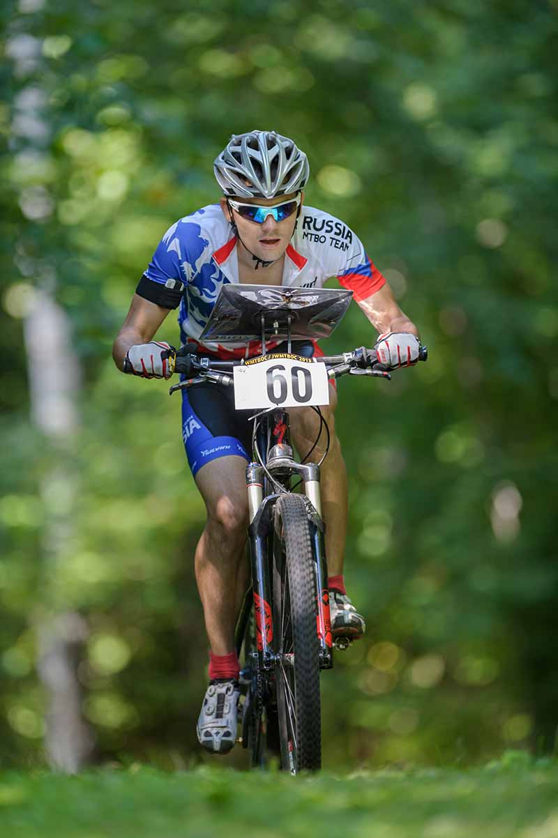
Orienteering on bicycles looks like a winter set direction. Instead of tracks, the map shows roads and the speed of movement along them, as well as places dangerous for cyclists, for example, logs.
Trail-O- orientation for disabled people. Competitions in this form are organized on a principle similar to marking. The route and the sequence of the route are determined in advance. There are several prisms at the checkpoints, and the participants need to determine which one most closely matches the map and legend. Legend - description of the location of the item. It may turn out that all the prisms are wrong. The winner is the one who made the least mistakes.
Participants may have different disabilities, so the time to complete the distance is not taken into account.
Rogaine- long-term orientation.
Unlike the classic format, rogaining competitions last from several hours to a day. During this time, participants must find as many checkpoints as possible, and the order of their passage can be arbitrary.
Sport is developing, and other disciplines are emerging: orienteering in kayaks, in caves and labyrinths, sprint, night orienteering, etc.
Conclusion
Orienteering is a fun sport. The workouts combine running training, game moments and logic tasks. Competitions offer a versatile test of your capabilities.
We at the Running Lab really love orienteering. Many of our employees have been professionally engaged in it or are still doing it, were part of the national teams of Russia and took part in the World Championships.
If you are looking for new goals for yourself or want to diversify your running workouts, try orienteering.
The article was prepared by Dmitry Gavrilov and Svetlana Razumnaya.
Chapter 10. Orienteering
Orienteering competitions consist in passing a distance with a map and a compass and marking at control points (CP) located on the ground. An orienteer athlete needs to have high physical qualities, know the topography perfectly, master the compass perfectly and confidently read the map, quickly and correctly choose the path of movement in unfamiliar terrain, have high volitional qualities.
Orienteering in our country is a young, actively developing sport. At present, it is firmly included in the standards of the TRP complex and in the calendars of competitions of various ranks - from school to all-Union, which have been held since 1981 in the rank of the USSR championship.
Competitions are divided into the following types: orientation in a given direction, on a marked track, by choice. Relays can be held for all types. Participants cover the distance jogging or skiing. According to the time of the competition, there are day and night, one-day and multi-day, and by the nature of the offset - personal (the results are counted separately for each participant), team (the results of individual participants are counted for the team as a whole), personal-team (the results are counted separately for each participant and team in overall).
Orientation in a given direction- this is the passage of the checkpoints marked on the map and located on the ground in a given order. For the purpose of dispersing the participants, it is allowed to apply a different order of passage of separate parts of the distance by different participants, but in the end everyone must go the same distance. Single start is recommended for participants.
The result is determined by the time spent on covering the distance from the moment of the technical start to the finish. If a participant violated the control order or missed the control, his result will not be counted.
Orientation on a marked track- this is the passage of the distance with the mapping of the location of the checkpoints installed on the track. Most often, competitions are held in winter. The location of the control point is drawn on the map only at the next point by piercing it at the appropriate point with a punch or a needle. In the latter case, the puncture is marked with a colored pencil available on the checkpoint, crossing it crosswise. The last checkpoint is applied at the "turn of the last checkpoint".
For an error in drawing control over 2 mm, the participant receives a penalty time - 1 min. for every complete or incomplete 2 mm. The maximum penalty that can be imposed for an error in inflicting one control is 3 minutes. At distances of mass discharges, the maximum penalty is 5 minutes. The result of the participant is determined by the sum of the time spent on the distance and the penalty time. Ski orienteering championships are held every two years.
In optional orienteering, the participant at the start receives a map with marked control points. Each control is marked with a number that represents its "value" in points. The ultimate goal of the participants in this competition is to score the most points by looking for a control in a certain time, the same for everyone (usually 1 hour). Each athlete independently chooses the most valuable and realistic route for himself. Passing all checkpoints is optional.
Elective orientation for beginners- this is the passage of a given number of checkpoints from among those located in the competition area. The choice of control points and the order of their passage is arbitrary - at the discretion of the participant. Repeated access to the same checkpoint is counted only once. Participants start - general or group. All controls available in the competition area and their designations are plotted on the map. In the area of the competition, 1.5-2 times more CP is set than the amount that needs to be found. The participant's result is determined by the time spent on the passage of a given number of checkpoints.
The equipment of the orienteering competition distance includes: the point of issue of maps, the starting point, the point of orienteering, control points, the line and the place of the finish, and in competitions on a marked track - the path of movement of the participants.
For the equipment of the control point and the starting point of orientation, a sign in the form of a trihedral prism with a side of 30x30 cm is used. Each face is divided by a diagonal from the lower left to the upper right corner (at the top - a white field, at the bottom - orange or red).
Orienteering is one of the few sports where competitors act individually, out of sight of coaches, judges, spectators, even rivals. Therefore, to achieve the goal, you need good psychological preparation, the manifestation of perseverance, determination, courage, and self-control. There are two main components in the technical training of an orienteer athlete: orienteering technique (working with a map and compass) and terrain movement technique (running or skiing).
Initial training of an orienteer
Determination of distances. One of the most important ways to orient yourself or determine your location is to measure distances. During the course of the route, the orientator constantly has to solve problems related to the estimation of the distance. Usually, two methods of determining distances are used - by eye and in steps.
The eye method is successfully used when driving along roads, clearings, in a rare forest, in a field and in a meadow. This method requires constant training, during which the athlete estimates the length of the various segments and then measures them using a map or strides. With a certain skill, the measurement error can be relatively small, up to 5%.
Measuring distances in steps is the most common method and also requires certain skills. Most often, distances are measured by counting pairs of steps under the left leg. Preliminarily, on different types of soil, the number of pairs of steps in a 100-meter segment is determined, which are run repeatedly and at different speeds. The resulting averages are tabulated and then used to measure distances during the competition.
Determination of directions. First of all, the determination of the northern direction is necessary for the correct orientation of the map, for which the map and the compass are placed side by side in a horizontal position or the compass is placed on the map. The map is then rotated so that the north ends of the magnetic meridian lines are facing in the direction that shows the north end of the compass needle. In sunny weather, you can roughly determine the cardinal points by the sun, using a watch for this.
When determining the direction of movement or direction to a separate landmark, a compass is used, with the help of which the azimuth to a separate landmark or control point is determined, where the athlete rushes. To do this, first, the north direction is determined by the compass, and then the angle between the north direction and the object of interest to us, that is, the azimuth is calculated. The azimuth is measured clockwise from 0 to 360 °.
In orienteering use special sports compasses (Fig. 12). The box of such a case, where the magnetic needle 3 is placed, is filled with a special non-freezing liquid (a mixture of alcohol and glycerin). Thanks to this, the magnetic needle quickly calms down and almost does not hesitate when the athlete runs. The compass body, together with the dial 2, is mounted on a plexiglass plate, along the edges of which there are divisions of the scale ruler 5 for measuring distances on the map. Some models of sports compasses have a magnifying glass 6 to facilitate reading of small details of the map, a guiding arrow 7, and are equipped with a pedometer 8 to record hundreds of pairs of steps taken, which frees the athlete from the need to memorize them.
To determine the direction of movement on the ground (movement in azimuth, Fig. 13) between two points specified on the map, for example, between the start and KP 1, you need to perform the following operations:
1) align the edge of the compass plate with the line connecting the points "Start" - KP 1;
2) turn the compass flask so that the double marks on its bottom "look" at the northern edge of the map;
3) keeping the compass horizontal, turn in place until the north end of the arrow aligns with the double line on the bottom of the flask. Mentally extend the direction along the compass plate - this will be the azimuth direction at KP 1.
For beginners, you can conduct competitions without a map - in azimuth and distance (azimuth route, Fig. 14). The participant is given a card with a task (for example, KP 1: 15 ° -250m; KP 2: 270 ° -300 m, etc.). Orienteers run or pass a given route, checking in at checkpoints. To do this, you must be able to determine the distance by counting steps.
Reading the map and comparing it with the terrain. One of the main orienteering techniques is reading a map against the terrain. Reading a map means to perfectly study the conventional signs, to be able to determine the general characteristics of the terrain from the map, the spatial relationship of individual landmarks, and to recreate a detailed picture of the terrain using conventional symbols.
Reading a map on the ground begins with orienting it to the north. After performing this operation, the spatial locations of landmarks on the terrain and on the map will correspond to each other.
In addition to orienting the map by the compass, they also use its approximate orientation by local objects and celestial bodies or by landmarks and directions between objects.
Memory plays an important role in card reading technique. The point of using memory is so that what you see on the map can be analyzed on the go. There are many exercises and tasks for training memory and working with the map. For example:
1) remember in 5-10 seconds. (fig. 15);
2) find the numbers in order from 1 to 50 (fig. 16);
3) transfer the CP from one card to another at a distance of 5-10 m;
4) fold the card (stick the sections of the card on the cubes; select the corresponding sections, fold the card);
5) write a topographic dictation;
6) read the map along the line of the magnetic meridian from south to north;
7) make a layout of the terrain for this map;
8) draw from memory parts of the map after studying it for 3, 2, 1 minutes;
9) read the proofreading text;
10) make a map from pieces (for a while).
To work with the map and compass, there are various exercises and tasks that you can get acquainted with while studying the literature.
Much painstaking work on the study of orienteering techniques is carried out in specially equipped classrooms and training grounds. The classroom or classroom should have the following inventory: an epidiascope, a slide projector, a movie projector for showing educational films, a tape recorder, compasses, tablets, educational posters, various diagrams, graphs, a set of educational maps, a three-dimensional model of a polygon or terrain. On the information boards are posted: a calendar plan, announcements, a ranking table, protocols of past competitions, a list of bureaus of the orienteering section, interesting clippings from newspapers and magazines, a list of recommended literature, compass models, a table of conventional symbols. After the competition, maps with the routes of the winners of the competition are posted.
To speed up and improve the learning process, various devices, simulators, training stands, programmed learning systems, and machine control devices are created.
The choice of the order of passing the checkpoint and the methods of orientation. First, the most optimal order of passing the checkpoint is determined, which allows to cover the distance in the shortest time. To do this, you need to carefully study the map in order to get a general idea of the terrain, view the points of the checkpoint and approaches to them, choose the most convenient from several options for passing the checkpoint. Here, the orientation methods are used that are most appropriate for a given area.
The method of orientation is a set of certain techniques, the use of which is most expedient when passing a distance or its individual sections. Depending on which technical element is the leading one, a number of orientation methods can be distinguished.
1. Heading (coarse azimuth). It is used on long stages, on poor landmarks and well-traveled terrain, when there is a large unambiguous landmark near the checkpoint. The athlete runs not to the control, but to this landmark. Direction control is carried out by periodically looking at the compass, as well as by the sun and intermediate landmarks. There is almost no control over the distance.
2. In the direction of reading the map. Having determined the direction of movement near the initial control, the athlete tries to maintain this direction in the future, controlling himself according to intermediate landmarks. The method is applied on well-traversed and visible terrain, not particularly rich in landmarks, at stages 400-600 m long. Distance control is based on intermediate landmarks.
3. In azimuth. The athlete uses, as a rule, two elements of orientation: accurate bearing and accurate determination of the distance by counting steps. This one of the most reliable methods is preferable on poor landmarks, when you need to get to a point object, for example, a hillock in a difficult forest, 150 m from the crossroads of glades.
4. In azimuth with map reading. A detailed reading of the map and constant comparison of it with the terrain are added to the movement along the exact azimuth. The method is expedient when driving along terrain saturated with the same landmarks, more often when moving from a reference landmark to a checkpoint, and is the most accurate and complex.
5. Running on linear landmarks. The participant uses mainly linear landmarks for running: roads, clearings, forest boundaries. The method is used when passing long stages on flat terrain with difficult forest and a large number of linear landmarks, it is the fastest, but it leads to an increase in the length of the run distance.
6. Running with accurate map reading. The athlete uses for movement various forms of relief, various objects, clearly visible from one another. The method is applied on an area with good visibility and rich landmarks. Determination of the direction of movement and distances is carried out according to the relative position of objects.
Choosing a rational path of movement. The orienteer, taking into account his abilities and training, tries to find the optimal path of movement to the checkpoint by reading the map. At the same time, the chosen path should be simple, reliable and traversed in the shortest possible time.
Before choosing a route option, it is imperative to determine a characteristic landmark (binding) near the checkpoint, from which you can simply and reliably get to the checkpoint. Only then should you choose the path to the control panel through this binding.
Beginners should choose simpler, albeit relatively long, options along clear landmarks (roads, clearings, borders) or along open areas, using reliable anchors.
Organization of orienteering competitions
Selection of the competition area and preparation of the circulation of sports cards. For the competition, forested areas of the terrain with an area of 2-4 km 2 are selected - city parks and recreation areas located near the educational institution. Areas of mass competitions must meet certain conditions (convenient access to the start site by public transport; an area of at least 2 km 2; good landmarks that limit the competition area; absence of dangerous places; sufficient forest passability; availability of shelters from bad weather in the start-finish area).
One of the important stages in the preparation of mass competitions is the preparation of the circulation of sports cards. In a number of cities, they are made centrally by city or regional committees for physical culture and sports and then implemented among organizations conducting mass competitions. In other cases, cards for competitions are purchased from physical education collectives or sports societies that have enough of them. The production of large quantities of sports cards at once allows them to be used for 3-4 years. After this period, the cards are corrected and the circulation is published again. Covering the cards with a transparent film allows you to protect them from rain during the competition, significantly lengthens their service life.
As a rule, a memo in the form of a table of conventional signs is printed on the cards, which makes it easier to study them and helps when passing the distance of the competition. For the competition of students and pupils it is recommended to use multi-color cards and only in their absence to resort to black and white, made by a photographic method.
Equipment for the course and competition center. For the equipment of the center of competitions and distances, 3-4 people are attracted, who have experience of work as heads of the distance in orienteering competitions. The most important thing in the work of the distance service is the planning of the route, in which one should not get carried away with the setting of complex control points, but also one should not allow the competition to turn into a cross on the roads.
The distance must be planned so that its parameters correspond to the requirements of the TRP complex specified in the standards. If the terrain features do not allow to withstand these parameters, small deviations in the direction of decreasing the distance with a simultaneous increase in the number of control gears are permissible.
To prepare the distance in accordance with the recommended parameters, it is advisable to locate the checkpoint so that the average distance between them is about 500 m.This corresponds to their placement at the tops of equilateral triangles with a side length of 500 m.
For KP equipment, either standard red-white prisms or stationary red-white columns are used. Sometimes trees, the corners of fences, pre-painted are used for the control panel. The checkpoints are equipped with marking devices with which the competitors are most familiar. Most often, composters and colored pencils are used for these purposes. Of the various types of composters, the most convenient for participants and judges are composters with typewriter letters. They emboss a letter or number on the participant card. 2-3 composters are installed on one control room, depending on the number of participants.
When using pencils, they are firmly attached to a wire or rope to the BC. At each checkpoint, 2-4 pencils of the same color are hung. They need to be selected in such a way that there is no KP with the same or similar set of pencils. Pencils are bluntly sharpened on both sides and tied in the middle.
The start and finish points are equipped according to which form of start will be used in the competition (group, general or separate). When holding mass competitions, a separate start is usually used, which allows, according to the results of the competition, to assign mass categories to the participants. With a separate start, greater independence of the participants at the distance is also ensured.
With a large number of participants, the dispersion system is used at the first checkpoints. To do this, at the start, they are assigned the obligatory first control points by a corresponding mark on the card or participant card. Control over the mandatory passage of the indicated checkpoints is carried out with the help of controllers who are located 2-3 checkpoints closest to the start.
When equipping start and finish corridors, garlands of multi-colored flags are used, as well as start and finish boards. The finish is arranged in such a way as to ensure the reception of participants from all possible directions. To count the judges' time, a flip clock-scoreboard is installed in a conspicuous place in the start-finish area.
It is recommended to equip an information board in the start-finish area. Samples of filling out control cards, control cards of the competition and operational information about the preliminary results of the finishing participants are posted on it.
Summing up the results of the competition. The processing of the competition results is carried out by 2-3 secretary judges. They use the cards of the finishing participants to calculate the results, and also check the correctness of the mark at the checkpoint. In each cell of the control card, any mark with a pencil hanging on the control card or an imprint of a punch must be made. The number of marks must correspond to the number of checkpoints.
In case of ambiguity with the mark, the participant is summoned to the panel of judges and the question of fulfilling the standard is decided on the spot. Often the reason for the violation of the mark is lack of awareness, accident. In such cases, it is allowed to read off the results by reducing it by one point (when determining the team championship) or adding a penalty time for an unbounded or unmarked control. If more than one control is not taken or other violations, the result will not be counted, however, the athlete has the right to re-participate in the competition on one of the following days according to the schedule.
On the basis of the processed cards, a personal competition protocol is drawn up separately for men and women. It indicates the surname, initials of the student or student, the number of the study group, the result shown, the sports category performed and the norm of the TRP complex, as well as the number of points earned by the participant.
When holding a team championship, they also make up a protocol of the competition separately for the team results, which indicates the number of points scored by the members of the group and the place taken. The minutes are drawn up in two copies.
as a sport
Orienteering is a young, actively developing sport that is gaining more and more recognition in our country. Wide accessibility, exciting wrestling on the track, the beauty of the surrounding nature - all this contributes to the popularity of orienteering.
Orientation on the ground combines physical and mental stress against the background of positive emotions in constantly changing external conditions, and also requires athletes to quickly and accurately assess the current situation and the ability to think in conditions of great physical stress.
As a result of communication with nature, an orienteer develops a number of valuable qualities: observation, endurance, willpower, the ability to navigate in a difficult environment. The motor and autonomic functions of the body develop and improve. Staying in woodlands has a beneficial effect on hardening the body. Orientation is a valuable means of physical influence on the human body. Two tendencies are clearly visible in the development of orienteering: the first is the development of mass forms of training, which have a purely health-improving orientation; the second is to improve the system of training and improving the skills of highly qualified athletes.
Terrain orienteering is one of the few sports in which competition participants act purely individually, out of sight of coaches, judges, spectators, even rivals. Orienteering competitions are a serious test of strength, speed, endurance and volitional qualities of athletes, the ability to think productively and make decisions against the background of developing fatigue. The essence of the competition is to identify athletes who are the fastest, using a map and a compass, to overcome a certain route on unfamiliar terrain through checkpoints fixed on the map and terrain. While competing in orienteering on the terrain, the athlete overcomes many kilometers by running, constantly at the same time determining his location, checking the terrain with the map, choosing the direction of movement and checking the correctness of the plan using a compass, evaluating the distances on the map and striving to accurately measure them on the track.
The main task is to choose the optimal path of movement and effectively implement it - the orienteer tries to perform it not only as accurately as possible, but also with the least amount of time. To achieve high sports results, in addition to good physical fitness, an orienteer athlete needs to know the topography perfectly, be able to use a compass, quickly and correctly choose the path of movement in unfamiliar terrain, and have well-developed volitional qualities. The result of an orienteer athlete in competition is made up of various factors that have a joint effect, mutually influencing each other and coming to the fore in turn in specific conditions. The success of the competitive activity of orienteers depends on many aspects of training: physical, technical-tactical and psychological. Each of these sections consists of a large number of indicators, and the lag even in one of them can significantly affect the result in competitive activity. Therefore, one of the main tasks of an athlete and a coach is to achieve a stable balance between these qualities and further bring them to automatism. Orienteering refers to cyclic sports with a predominant manifestation of endurance. It has a lot in common with cross-country running. However, there are also fundamental differences. This is a pronounced unevenness of running - from fast accelerations to full stops. But, perhaps, the most significant feature of running in orienteering on the ground should be considered the fact that it is only an auxiliary means, and not the meaning of the competition, as in athletics.
Physical training
Physical training of an athlete is a process of developing physical qualities - endurance, strength, speed, agility, flexibility, coordination abilities.
In orienteering, as in other sports, there is a distinction between general and special physical training.
General physical training (GPT) of the orienteer aims at the all-round development of the athlete. Its means are a wide variety of physical exercises: cross-country running, gymnastics, flexibility exercises, coordination, with and without weights, sports games, swimming, cross-country skiing, rowing, etc.
The tasks of special physical training (SPP) in orienteering are to improve the physical qualities that are most characteristic for this kind of sport: special and power endurance, coordination abilities. The means of SPP are: running on training and competitive tracks with orienteering, cross-country crossings, running and special preparatory exercises aimed at selective development of functional systems and muscle groups involved in the manifestation of endurance, strength, speed, dexterity.
The indices of physical readiness mean the factors that determine the ability for orienteering running. These are endurance, strength, speed, flexibility, range of motion, as well as mastery of coordination of movements in the process of performing a competitive exercise.
Indicators of technical skill of an orienteer are associated with specialized orienteering techniques. The technical skill of an orienteer sportsman is the mastery of those techniques that are used to solve orienteering problems in the process of competitive activity.
Orienteering tactics is a set of rational actions of an athlete aimed at achieving good results in competitions. Tactically thinking and acting correctly means solving orienteering problems in the shortest possible time, with the least expenditure of effort and taking into account the changing situation in the competition.
Psychological preparation in orienteering is essential in achieving high results. The orienteer must be able to adapt to the stressful situation arising during the competition so as to achieve the best result, taking into account the level of physical and technical-tactical readiness.
The importance of psychological indicators in orienteering is obvious, because mistakes are often made in situations that an athlete is quite capable of controlling.
In the psychological training of an orienteer athlete, they pay attention to the development of such mental qualities as memory, thinking, and attention.
The main technical means in the orienteering competitive activity are a sports map and a sports compass.
A sports map is a large-scale special map designed for orienteering and made in conventional signs, the special content of which is showing the terrain passability and the information content of objects. This is a detailed description of the terrain where the competition is supposed to be held. With the help of the map, the head of the distance plans the routes, equips them on the ground. An accurate, objective and informative map, made according to standardized recommendations and easy to read on the run, is the basis for a technically perfect distance, a guarantee of sports fairness. All sports cards must be drawn up in conventional signs and have certain qualities: accuracy, information content, objectivity, readability and completeness of the content.
A sports card is an attribute that accompanies an orienteer, helping him to maximize his skill at the proposed distance.
The sports card can be divided into two functions. The first is a reference. The map gives an idea of the competition terrain and shows the proposed distance. And the second is operational. Here, the map is the tool with which the athlete implements the proposed distance.
In terms of detail and accuracy, modern sports maps have no analogues either in the military, or in tourism, or in any other practice.
A sports compass is a device that indicates the direction of the geographic or magnetic meridian. With the help of a compass, they determine the direction of the path and the direction to landmarks. For orientation on the ground, a large number of different compass systems are used: magnetic, hygroscopic, solar. In orienteering, only magnetic compasses are used.
Orienteering technique
Orienteering is a kind of endurance group sport, which, in addition to the requirements for versatile physical training, also requires many other skills and abilities.
Orienteering differs from many other sports in that situations requiring the manifestation of technical skill are never repeated, except perhaps for work at a checkpoint. Typically, various technical skills and techniques are learned through repeated repetition until the actions are automatic and consistent with the correct execution pattern. The orientator must also formulate the most appropriate performance models for himself in all areas of technical skill and be able to apply them in accordance with the requirements of an ever-changing environment.
Possession of the basics of technology creates the prerequisites for solving the approximate tasks set by the head of the distance. A good orienteer uses all the techniques learned in parallel and sequentially and is able to choose the most appropriate solution model or a derivative from it.
With the accumulation of experience in training and competition, the orienteer develops a good basis of technical skill and the ability of orienting thinking, which leads to a decrease in the number of errors and increases the reliability of execution.
Technical actions are called methods of orientation, sometimes methods, methods. Technical operations are called elements of technology. In the technique of running on terrain, the action is itself running on a specific type of terrain, and operations are its components, such as pushing off, swinging a leg, placing a foot.
Orienteers are characterized by large individual characteristics of running technique, which is associated not only with differences in the development of physical qualities and body structure, but also with different conditions for training and competitions (ground, relief).
The most important thing for an orienteer is the art of regulating the speed of movement, based on a correct assessment of physical and technical capabilities. With reliable walking, every orienteer is able to successfully overcome even a very difficult track, but when running at maximum speed, even the most experienced orienteers of the elite are unable to do this. Therefore, on any part of the route, you need to move so as to cope with the tasks of orientation at a given speed, to control your location on the map.
With an increase in the level of technical skill, the orienteer can increase the running speed. The results are most noticeably improved if the orienteer is simultaneously able to raise the level of technique and increase the running speed. There are no style points in orienteering; you need to move quickly, decisively and efficiently.
Techniques used by athletes both in training and in competition: compass control, movement in azimuth and its determination; reading terrain and maps; their comparison; determination by the athlete of his position on the map; memory card; observation; use of modern equipment; methods of searching and taking control points; counting distances, using linear and areal landmarks; transfer of control points and distances for a while; movement without a compass; running with card reading; development of spatial imagination; orientation of the map by compass, sun, linear and areal landmarks; height control.
Introduction
Orienteering is one of the most specific kinds of sport, which combines high physical and mental stress against the background of great volitional and emotional stress, aimed at independently solving a number of practical problems. During hard physical work, you should always make observations from the surrounding area and maps, and also often adapt to unexpected situations and conditions. To achieve a good final result, an orienteer sportsman must be able to concentrate, relax, create mental images from the surrounding area (Akimov V.G., 2005).
Orienteering is one of the few sports in which competition participants act purely individually, out of sight of coaches, judges and spectators. To achieve the goal, you need high psychological preparation, the manifestation of perseverance, decisiveness, self-control. Systematic work on the development of technical and tactical skills contributes to the development of cognitive mental processes and the growth of sportsmanship. (B.I.Ogorodnikov, A.N. Kircho, L.A. Krokhin, 2002).
Psychological skills and strategies can be used to optimize and enhance physical and technical fitness. Also, it is important to consider psychological training in parallel with physical and technical training, which should be carried out regularly. Just as increasing speed in difficult terrain is associated with regular physical and technical training, so the ability to cope with the pressure of competition may be associated with psychological skills training (MTS).
From the above judgments, the topic of our course work "Psychological training in orienteering" was chosen.
The purpose of the work is to study psychological training in orienteering.
To achieve this goal, the following tasks were set:
1. To study the features of orienteering as a sport.
2. Expand the concept of psychological preparation
3. Consider the specifics of the psychological training of an orienteer athlete
The object of the research is the training process of orienteering athletes.
The subject of the research is psychological training in orienteering
When writing a term paper, the method of studying and analyzing literary sources was used.
Orienteering as a sport
The specifics of orienteering
Orienteering, according to N.D. Vasil'eva (2004), is an independent sport, the essence of the competition in which is to identify athletes who are able to overcome a certain route using a compass and a map faster than others through an unfamiliar area through control points (CP) fixed on the map and terrain. The results, as a rule, are determined by the time of passing the distance (in certain cases, taking into account the penalty time) or by the number of points scored.
The most common type of orienteering competition, both in our country and abroad, is orientation in a given direction (Elakhovsky S.B., 2003; Vasiliev N.D., 2004). In this type of competition, the participant must as quickly as possible find on the terrain with the help of the map KP in the same sequence defined for all. Participants choose the path from one control point to another at their own discretion. In addition, in Russia, competitions on a marked track and by choice are officially recognized and are very popular. The essence of the competition on a marked track is that a participant, overcoming a marked (marked) distance with control points installed on it, must determine their location and mark them on the map with a puncture and a puncture in the card. Orientation by choice is the passage of a checkpoint from among the available in the competition area, while the choice and order of passing the checkpoint is arbitrary, at the discretion of the participant.
Also, according to the rules of orienteering competitions, there are two more types of programs - orienteering on trails or orienteering for the disabled and rogine. The first type allows people with limited motor abilities to take part in competitions and consists in passing the control points marked on the map in a given sequence and choosing the true control sign from several established on the ground. Rogaining - passing a distance of your choice using a map of scale 1: 25000 or 1: 50,000 with the planned result of the winner being 300 minutes. These competitions are team competitions.
Orienteering competitions differ in the mode of movement: jogging or skiing, cycling, walking and wheelchairs, which have their own specific characteristics.
All types of orienteering are united by one main feature - the availability of a detailed large-scale sports map of the area on which the competitions are held, and the use of a compass.
A sports map is a large-scale special scheme that lacks a coordinate grid, true meridian lines and operates a special accuracy system for planned, angular and altitude measurements in accordance with the requirements of the IOF and the FSO of Russia. To draw up sports maps, conventional signs are used - symbols that convey the characteristics of the landscape of various types of terrain and its characteristic features, as well as signs used in sports maps at international competitions (Akimov V.G., 2005).
During the competition, an orienteer athlete must not only quickly move along the distance, but also simultaneously solve a number of specific tasks: read the map, compare it with the terrain, choose the optimal paths to the control room, etc. All these actions constitute the athlete's technical training, but what about includes psychological preparation, we will consider in our work.
Orienteering is a run in a given direction: an athlete with a map and a compass must go the distance, checking in at several checkpoints. You need to move over rough terrain (usually through forests and parks), pass control stations in a special order. This sport emerged from the military exercises that were conducted for the Scandinavian and British soldiers. The founding father is considered to be Swedish Major Ernst Killander, president of the Stockholm Amateur Sports Association. He came up with the rules and hosted the first ever competition in 1918.
Tells psychologist and psychophysiologist Tatyana Fadeeva, 31 years old, Candidate Master of Sports, medalist of the Moscow Region Championship and the Russian Azimuth Federal Competition.
“Orientation teaches you to rely only on yourself,” says Tatiana. - There are no fans or rivals nearby, you are alone with your distance. In fact, this is a metaphor for life, with which you are also always tete-a-tete, and you need to move forward, fight fears, laziness, unwillingness to think. I made a mistake - it is not a fact that I lost: where it is difficult for you, it is difficult for the rest, competitors could also make a mistake. Therefore, if you get lost, you cannot rush and panic, you need to pull yourself together and make an informed decision. Stop, remember at what point you still knew where you were, return, re-orientate and continue moving. Everything is like in life. "
It is not that simple. At high aerobic loads, it is difficult to maintain attention (during training, beginners are given texts and puzzles that must be read and solved on the run - just try and you will understand how “great” it is). But after all you need to follow the road, check the route, figure out how to get over obstacles... And do not mix up the checkpoint numbers. Although this is the most interesting thing. Plus useful: there is little in life that can be useful as the ability to think quickly in a stressful situation. (Check out the stress management guide.)
“Orienteering is a unique combination of physical and mental load,” says Tatiana. - You don't just run, but you also think that your head is 150% loaded. You are not distracted by extraneous thoughts, you forget about problems and just merge with the movement. Such immersion in the process can be achieved only in yoga, but only if you are a very experienced practitioner.
Competitions take place almost every weekend, and there I dump the load that I have accumulated over the week. This is my coping strategy, a personal way to deal with stress. Cortisol and other stress hormones are best released when a person is running or wrestling, and orienteering is running and wrestling in one bottle. Plus, you are alone with nature and at this moment you take off all social masks - you are just an orienteer. You accept yourself for who you are. "
In Russia, orienteering is not as popular as, say, in Scandinavia. In Finland, the president comes to the main baton of Yukola, a whole town with showers and canteens grows in the forest, and everything that happens is filmed from helicopters. But we also have large events gathering several thousand participants. Not only professionals can compete: groups are open to everyone - there are also children, and even pensioners, by the way.
“Orienteering suits anyone, except perhaps the glamorous young ladies who are afraid to ruin their nails or scratch their knees,” says Tatiana. - It's dirty sport. We run not on asphalt, but along forest paths, returning from a distance grimy and sweaty. Whatever the weather, the baton is not canceled. And every time after the competition, I have three machines for washing. But on the other hand, you feel an incredible cleansing inside yourself. As a specialist, I can say that orienteering is a great help in solving any psychological problems... Even if you can't run for physiological reasons, you can just walk, orienteering is not about speed at all. And this is always positive. When you find a checkpoint, you feel delight, exultation. And you have such small victories - 20-30 at a distance. You come back happy, no matter what mood you start with. "
Orienteering Championship of Russia, Miass. “All women exercising look young,” says our heroine. And we agree with her.
Go in for orienteering
Most orienteering clubs are geared towards teaching children. Adults are rarely attended, so you will most likely have to negotiate a personal program with a coach. Usually, one lesson with a map is enough to learn the legend and understand how to orient the plan to the north. And then - practice. The second option is to bring a child to the club and run with him, as many do. The address of the institution closest to your home can be found on the moscompass.ru website or http://o-sport.ru/map.php.
If you do not really like the idea of running through the forest in search of checkpoints, but in general attracts you to orienteering, the game "Inakor" is suitable - Internet-based orienteering, a mix of orienteering, city quests and geocaching (search for treasures hidden by someone using GPS ). You register on the website msk.inacor.ru, download the map (there are all Moscow parks, including those little known to the general public), the route and try to pass it faster than anyone else, checking in at the checkpoints. The fastest get prizes - virtual and real.
What you need for orienteering
A CO adept requires minimum equipment:
- correct spikes;
- comfortable shape - better nylon, so that the branches do not cling;
- compass;
- electronic chip, it is applied to the station sensor.
Yoga for competition preparation
Yoga prepares your body for cross-country running and your mind for hard work. Practice these asanas regularly, gradually increasing the time you stay in each pose.
Virabhadrasana I (warrior pose I)
Strengthens the muscles of the legs, opens the hip joints, develops coordination, trains endurance.
- Stand straight. While inhaling, jump apart your legs, spread your arms to the sides. Now turn your palms up, lift the outstretched limbs and connect your fingers.
- Inhale, exhale, turn the toe of your right leg, pelvis and torso to the right 90 degrees, and turn your left foot slightly inward.
- Inhale and as you exhale, bend your right knee to a right angle. Pull your head back slightly and look up at your thumbs.
- Stay in this position as much as possible. Then inhale, return to the starting position and repeat the pose, changing legs.
Virabhadrasana III (warrior pose III)
Strengthens the muscles of the thighs, legs, buttocks, develops the ability to maintain balance.
- Stand up straight. While inhaling, jump apart your legs, spread your arms to the sides - and go into the "Virabhadrasana I" pose (the one that was before).
- Inhale, exhale, now bend over to your right thigh, stretch your torso and arms forward, palms together.
- Lift your left leg off the floor and slowly lift it to parallel with the floor (while straightening the supporting leg). Look down, neck and back are in line.
- Remain as much as possible, then as you exhale, slowly lower your left foot to the floor, lifting your body up. Return to Virabhadrasana I, and then to the starting position. Repeat by changing legs.
Chaturanga dandasana (four-leg staff pose)
Strengthens the muscles of the back, abdomen, arms and legs, disciplines the mind, and helps to stay focused.
- Starting position - lying down (feet and straightened arms shoulder-width apart, body stretched from heels to crown).
- Resting on the floor with the bases of your palms, slowly bend your elbows, pressing them to the body.
- Lower the body so that it rests on four anchor points parallel to the floor. If you're a beginner, you can put your knees and forearms on the floor.
- Stay in this position as long as possible.
The editors would like to thank the FITNESS HOLDING project for the help in organizing the shooting.